

From the highlands of Luzon to the limestone karts of Palawan, here’s everything you need to know about how many islands are in the Philippines.
The first time I ever visited the Philippines, I remember wondering if it would ever be possible to visit every single Filipino island. The sheer number of islands in the archipelago is staggering, with an estimated 7,641 islands and atolls at the last count. The thing is, it’s a count that’s constantly changing, and even as I visit more and more islands on more and more trips to the Philippines, I think it’s safe to say I’ll never visit them all!
But that’s what I love about the Philippines. Although this intricate collection of land masses is separated into the three primary regions of Luzon, Visayas, and Mindanao, each of the regions and islands presents a unique opportunity to discover new languages, cultures, cuisines, histories, and landscapes. No two islands are the same, and you can spend a lifetime hopping between islands without ever visiting them all.
If you’re planning a trip to one of Southeast Asia’s most underrated destinations, then keep reading, as I explain how many islands are in the Philippines.
Table of Contents
How many islands are in the Philippines?
The Philippine archipelago is composed of 7,641 islands, a figure that often fluctuates due to tidal changes and updated geographical assessments. These islands are dispersed across the western Pacific Ocean and contribute to the country’s total land area of approximately 300,000 square kilometres. The islands are organised into three primary geographical subdivisions: Luzon to the north, Visayas in the centre, and Mindanao to the south.
The islands vary in size and topography, ranging from expansive land masses like Luzon and Mindanao, which are replete with mountains, plains, and urban areas, to small, uninhabited islets that barely rise above sea level. Luzon is the largest island and serves as the political and economic heart of the nation. Here, you’ll find Metro Manila, the dense and sprawling capital, as well as important cities like Quezon City and Angeles.
In contrast, the Visayas region is known for its smaller, more idyllic islands and a more laid-back lifestyle. Cebu, Bohol, and Negros are some of the well-known islands in this group, each with its distinct character, culture, and natural environments, including coral reefs and fertile farmlands.
Mindanao, the second-largest island, has its own unique character. This southern island is less visited by international tourists and offers a blend of indigenous cultures and natural landscapes, from highland plateaus to fertile valleys and a complex system of rivers and lakes.

Read more: The Best Legazpi Tourist Spots, Philippines (And a Few Things to Eat Too)
How do they count the total number of islands in the Philippines?
The count of the number of islands in the Philippines is based on official geographical surveys carried out by the government’s mapping agency, the National Mapping and Resource Information Authority (NAMRIA). These surveys often involve both aerial and marine reconnaissance, as well as satellite imagery, to get an accurate count. NAMRIA also relies on scientific methods that include measuring the elevation of land masses above sea level and determining their permanence, irrespective of tidal conditions, to qualify what constitutes an ‘island’.
The official count can therefore change over time due to a variety of factors. Natural events such as volcanic eruptions, earthquakes, and erosion can alter the landscape, leading to the emergence of new islands or the merging or disappearance of existing ones. Additionally, improvements in mapping technology and methodology can lead to more accurate counts. For example, the official count was updated from 7,107 to 7,641 islands in 2016 after an extensive survey by NAMRIA that used more advanced counting methods and technologies.
It’s worth noting that while some islands are well-known and permanently inhabited, many are uninhabited and some even remain unnamed, making them challenging to count and catalogue comprehensively. Therefore, while the figure of 7,641 islands is the current official count, it’s important to consider it as subject to potential change due to both natural factors and advancements in mapping technologies.
What are the main island groupings in the Philippines?
The Philippines is generally divided into three main geographical regions, each comprising a group of islands. These regions are Luzon, Visayas, and Mindanao:
- Luzon: The northernmost region, Luzon is the largest in terms of both land area and population. The island of Luzon itself is the biggest in the Philippines and is home to the country’s capital, Manila, as well as other major cities like Quezon City and Makati. The region encompasses other significant islands such as Palawan, Mindoro, and the Batanes group near Taiwan. Luzon is known for its varied landscapes, which include the rice terraces of the Cordillera Mountains, the beaches of Batangas, and the volcanic landscapes like Mount Pinatubo.
- Visayas: Located in the central part of the archipelago, the Visayas is a complex group of islands that includes some of the Philippines’ most well-known islands like Cebu, Bohol, Negros, and Panay. The region is renowned for its beautiful beaches, such as those in Boracay, and excellent diving spots, including the Tubbataha Reefs. Visayas is a hub of Philippine culture, with events like the Sinulog Festival in Cebu and the Ati-Atihan in Kalibo.
- Mindanao: The southernmost region includes the large island of Mindanao and the Sulu Archipelago, comprising smaller islands like Basilan, Sulu, and Tawi-Tawi. Mindanao is known for its rich natural resources, including Mount Apo, the highest peak in the Philippines. The region is diverse in culture, with a significant Muslim population, particularly in areas like the Autonomous Region in Muslim Mindanao (ARMM).

Read more: Philippines Food: The Best Filipino Dishes to Eat in the Philippines
What are the largest islands in the Philippines?
The largest islands in the Philippines, in terms of land area, are the following:
- Luzon: Covering an area of about 109,965 square kilometres, Luzon is not only the largest island in the Philippines but also the fourth-largest island in the world. It is situated in the northern part of the country and is home to Metro Manila, the capital region.
- Mindanao: Located in the southern part of the archipelago, Mindanao is the second-largest island with an area of approximately 94,630 square kilometres. It is known for its diverse landscapes, which include mountains like Mount Apo, the highest peak in the Philippines, as well as lakes, rivers, and fertile valleys. Mindanao is also known for its cultural diversity, including a significant Muslim population.
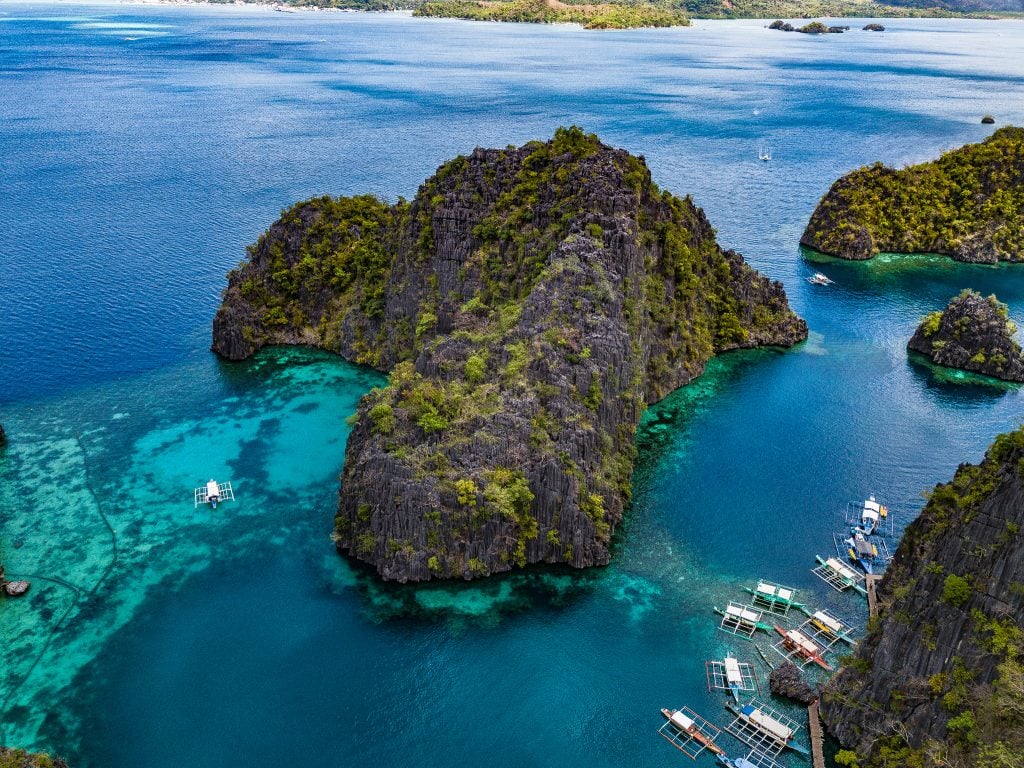
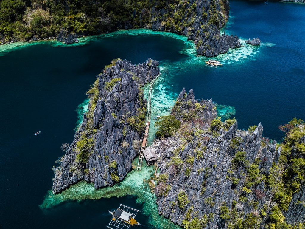
- Palawan: This island is situated in the southwestern part of the Philippines and is part of the Luzon group of islands. It covers about 12,189 square kilometres and is known for its rich biodiversity. Palawan is home to two UNESCO World Heritage Sites: the Tubbataha Reefs Natural Park and the Puerto-Princesa Subterranean River National Park.
- Panay: With an area of approximately 12,011 square kilometres, Panay is part of the Visayas group of islands. It is composed of four provinces: Aklan, Antique, Capiz, and Iloilo. The island is known for its agricultural lands and is a significant rice and sugarcane producer.
- Mindoro: Located off the southwestern coast of Luzon, Mindoro has a land area of about 10,572 square kilometres. It’s divided into two provinces: Oriental Mindoro and Occidental Mindoro. The island is known for its agriculture, as well as natural attractions like Mount Halcon and the Apo Reef.
- Samar: Part of the Eastern Visayas, Samar has an area of approximately 13,429 square kilometres. The island is known for its rugged terrain, which includes mountains, caves, and waterfalls.
- Negros: Situated in the central Visayas region, Negros has an approximate land area of 13,309 square kilometres. It is divided into two provinces: Negros Occidental and Negros Oriental. The island is known for its sugar production, earning it the nickname ‘Sugarbowl of the Philippines’.

Read more: The Ultimate Guide to the Islands in Coron
What are the smallest islands in the Philippines?
The Philippines is home to thousands of even smaller islands, many of which are uninhabited or have only seasonal human activity. Some of these islands are so small that they are more accurately described as islets or sandbars, lacking permanent structures and disappearing partially during high tide. Here are a few notable examples:
- White Island: Located off the coast of Camiguin, White Island is a popular tourist destination known for its powdery white sand. The island is uninhabited and is visible only during low tide.
- Sombrero Island: This is a small island located in Batangas that is renowned for its diving spots. It gets its name from its hat-like shape (‘sombrero’ means ‘hat’ in Spanish).
- Snake Island: Situated in El Nido, Palawan, Snake Island is famous for a naturally occurring sandbar that extends and curves like a snake, hence its name.
- Crystal Island: This island is part of the Hundred Islands National Park in Pangasinan. It’s a small islet known for its limestone formations and crystal-clear waters.
- Balicasag Island: Located in Bohol, Balicasag is a small, flat island that is a famous diving spot.
- Guyam Island: Part of the Siargao islands, Guyam is an uninhabited islet known for its white sandy shores and coconut trees.
- Capones Island: This is a small limestone island in Zambales, popular for its light station and for outdoor activities like snorkelling and camping.
- Kalanggaman Island: Located in Leyte, this island is known for its long sandbars extending from both ends.

Read more: White Island Camiguin: Is This the Whitest Sandbar in the Philippines?
Are all of the islands in the Philippines inhabited?
No, not all of the islands in the Philippines are inhabited. Out of the 7,641 islands that make up the archipelago, only about 2,000 are inhabited. The rest are either too small, lack fresh water sources, are used solely for specific activities like fishing, or are preserved as natural reserves.
Some of the uninhabited islands have become popular for tourism, and they may host seasonal activities or temporary structures like cottages and diving shops. For example, certain islands in the Palawan region are renowned for their natural beauty but are uninhabited, serving primarily as tourist spots or protected natural areas. Likewise, some islands in the Visayas are known for their pristine beaches and coral reefs and attract tourists for day trips but do not have permanent residents.
Are the Spratly Islands included in the Philippines’?
The Spratly Islands are not included in the official count of 7,641 islands that make up the Philippine archipelago. The Spratly Islands are a group of islands, atolls, cays, and reefs in the South China Sea that are the subject of territorial disputes among multiple countries, including the Philippines, China, Vietnam, Malaysia, Brunei, and Taiwan.
The Philippines claims parts of the Spratly Islands based on geographical proximity and historical factors, and it has occupied some of the islands and reefs, naming them the Kalayaan Island Group. However, the complex geopolitical situation and overlapping claims from multiple countries make the Spratlys a contentious issue both regionally and internationally.
Because of the ongoing disputes and the fact that they are not universally recognised as part of Philippine territory, the Spratly Islands are not included in the official count of Philippine islands provided by the National Mapping and Resource Information Authority (NAMRIA), the government’s mapping agency.
Read more: Is Mindanao Safe to Travel to?
A brief history of the Philippine Islands
The history of the Philippines, and its many islands, is an intricate story of indigenous cultures, colonial rule, resistance, and modern state-building, all set against the backdrop of its 7,641 islands. Geographically isolated by vast oceans and rugged landscapes, the archipelago has been both a cradle for diverse local cultures and a magnet for foreign powers.
The earliest inhabitants of the Philippines (their descendants are today known as the Aeta) are believed to have arrived through land bridges from mainland Asia around 30,000 BCE. Various ethnolinguistic groups settled in different parts of the archipelago, each developing its unique traditions and systems of governance. Notable early societies include the Tondo, the Rajahnate of Butuan, and the Sultanate of Sulu, among others. These early societies engaged in trade with neighbours such as China, India, and Indonesia, weaving the Philippines into a broader tapestry of Asian maritime culture and commerce.
In 1521, Portuguese explorer Ferdinand Magellan, under the Spanish flag, arrived in the Visayas. Though he was killed in battle, his arrival marked the beginning of more than three centuries of Spanish colonial rule. The Spanish were focused on Luzon and the Visayas, particularly Manila, which they established as the colonial capital in 1571. The southern island of Mindanao largely resisted Spanish control, retaining a strong Muslim identity. Throughout this period, the Spanish converted much of the population to Catholicism and integrated the Philippines into their global empire, connecting it to as far away as Mexico through the Manila Galleon trade.
Resistance against Spanish rule was frequent, with various uprisings and revolts punctuating the colonial era. By the late 19th century, the struggle for independence gathered momentum, influenced by global ideas of nationalism and liberty. Heroes like Jose Rizal and Andres Bonifacio emerged, leading to the Philippine Revolution of 1896.
However, independence was short-lived. Following the Spanish-American War in 1898, the Philippines was ceded to the United States. Despite initial resistance, most notably the Philippine-American War (1899-1902), the country became an American colony. The U.S. period introduced widespread English education, democratic governance, and modern infrastructure.
World War II saw the invasion of the Philippines by Japan, leading to years of hardship. In the aftermath of World War II, the Philippines faced the monumental task of rebuilding. Granted independence by the United States on July 4, 1946, the newly sovereign nation embarked on a path of political and economic development. The post-war years were marked by a series of administrations that each left a distinct imprint on the country. The era of Ferdinand Marcos, who took power in 1965, was particularly consequential.
Marcos declared martial law in 1972, citing communist insurgency and social disorder as justifications. His rule, which lasted until 1986, was characterised by human rights abuses, political repression, and widespread corruption. It wasn’t until the People Power Revolution, a peaceful uprising, that Marcos was ousted from power, paving the way for Corazon Aquino to become the first female president in Philippine history.
Since then, the Philippines has oscillated between moments of democratic promise and periods of political turmoil. Nonetheless, the nation has shown resilience and adaptability, maintaining a form of democracy and experiencing economic growth, even as it continues to grapple with social challenges such as poverty, inequality, and ongoing conflicts, particularly in the southern regions.

Read more: The Tagbanua: The Real Locals of Coron
Do any islands want independence from the Philippines?
The issue of independence or secession for specific islands or island groups is not a mainstream political discussion in the Philippines. However, the country has experienced various forms of regional unrest and calls for greater autonomy, most notably in Mindanao.
- Mindanao and the Sulu Archipelago: These areas have seen long-standing movements advocating for greater autonomy or independence for the Muslim-majority regions. The Moro National Liberation Front (MNLF) and the Moro Islamic Liberation Front (MILF) are two groups that have campaigned for Muslim autonomy. In recent years, the Bangsamoro Organic Law was ratified, creating the Bangsamoro Autonomous Region in Muslim Mindanao (BARMM) as a political entity with more significant powers of self-governance than its predecessor, the Autonomous Region in Muslim Mindanao (ARMM).
- Cordillera Administrative Region in Luzon: There have been movements advocating for greater autonomy for the indigenous peoples in the Cordillera region in Northern Luzon. However, these have generally not taken the form of calls for outright independence but rather for greater regional autonomy within the Philippine state.
Read more: Dark Tourism: The Hanging Coffins of Sagada
FAQ: How many islands in the Philippines?
Here’s an FAQ on the topic: ‘How many islands are in the Philippines?’:
Q1: How many islands are there in the Philippines?
A1: According to the latest official count by the National Mapping and Resource Information Authority (NAMRIA), the Philippines is composed of 7,641 islands.
Q2: How is the number of islands determined?
A2: NAMRIA, the government’s mapping agency, conducts geographical surveys that often involve aerial and marine reconnaissance, as well as satellite imagery, to arrive at the official count. Islands are measured for their elevation above sea level and their permanence, irrespective of tidal conditions.
Q3: Does the count change?
A3: Yes, the count can change due to natural events like volcanic eruptions, earthquakes, and erosion, as well as improvements in mapping technology. For example, the count was updated from 7,107 to 7,641 islands in 2016.
Q4: What are the main island groupings?
A4: The Philippines is generally divided into three main geographical regions: Luzon in the north, Visayas in the centre, and Mindanao in the south.
Q5: Which is the largest island?
A5: Luzon is the largest island, with a land area of about 109,965 square kilometres. It is also the most populous and includes the capital, Manila.
Q6: Are all the islands inhabited?
A6: No, a large number of the islands are uninhabited. Some are used only for specific activities like fishing or tourism.
Q7: What languages are spoken across these islands?
A7: The Philippines has around 175 languages, although only 19 are officially recognised. Each island or island group often has its own vernacular language or dialect.
Q8: Are there religious differences among the islands?
A8: While the country is predominantly Roman Catholic, there are areas, particularly in Mindanao, with a significant Muslim population. Other Christian denominations and indigenous beliefs are also present.
Q9: Are any of the islands disputed territories?
A9: The Spratly Islands in the South China Sea are a point of territorial dispute involving the Philippines and several other countries. However, these islands are not included in the official count of Philippine islands.
Q10: Where can I find more information on the geography of the Philippines?
A10: NAMRIA’s website, government publications, and academic journals are good places to start for accurate geographical information.

Hi! I just want to say this is an amazing and extremely informative article. It is a brilliant idea to section parts with questions. It makes reading and skimming easier and friendlier. I learned more about the Philippine islands in this article than I have in our textbooks haha. Good luck in your endeavors.
This post was super informative! I had no idea there were over 7,000 islands in the Philippines. The breakdown of the major groups and some hidden gems was really helpful. I’m definitely adding some of these places to my travel bucket list! Thanks for sharing!
Great information keep it up