

This is the story of Adam’s Bridge (Rama Setu), the legendary sand bridge once said to have connected India to Sri Lanka.
If you’ve followed my work for any length of time at all, then you’ll know how much I love exploring geopolitical and geographical oddities.
When I was travelling across Sri Lanka in May 2025, I had the chance to visit ‘Adam’s Bridge’, one of South Asia’s most fascinating geographical features.
Of course, I jumped at the chance. So here’s the story of the legendary sand bridge, known to Hindus as Rama Setu and in English as Adam’s Bridge, which is once said to have connected Sri Lanka to India.
Keep reading, or watch the video, to find out more:
Table of Contents
What and where is Adam’s Bridge?
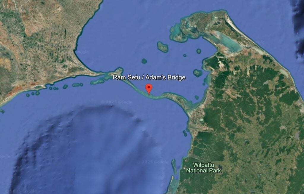
At the western edge of Mannar Island in northwestern Sri Lanka, the land stops abruptly at a pier. Beyond it lies a chain of sandbanks and shoals stretching in a jagged arc across the Palk Strait towards India. From the ground, it appears unremarkable, a scattering of reefs and shallows. From the air, it’s unmistakable: a natural bridge that once linked Sri Lanka to India
This is Adam’s Bridge, known to Hindus as Rama Setu. It is one of South Asia’s most legendary frontiers. A place where geology intersects with mythology, where imperial engineers saw opportunity, and where religious traditions continue to block modern development.
Adam’s Bridge extends roughly 30 kilometres between Sri Lanka’s Mannar Island and India’s Rameswaram. Satellite images show a striking curve of limestone shoals and sandbanks, evidence of a former land connection when sea levels were lower. Scientists suggest it may once have been a walkable isthmus, cut by rising seas thousands of years ago. Some say this land bridge is how unique species like elephants and leopards could have found their way from India to Sri Lanka.
When we reached the edge of the island and looked out across the Palk Strait, my guide Dhanushka explained the significance of Adam’s Bridge.
“This is the shortest gap between Sri Lanka and India,” he said. “This is a legendary and historical sand barrier. In English, we call it Adam’s Bridge. In India, they call it Rama Setu. It has huge religious, geographical and geopolitical importance.”
The religious significance of Adam’s Bridge
Geologically fragile, the shoals block major shipping from traversing the strait itself. Large vessels must detour south of Sri Lanka, adding time and cost. This has long tempted planners to consider cutting a channel through the strait. Colonial and modern governments have considered projects to dredge it, but religious sensitivities and environmental risks have blocked development every time.
The bridge has a strong place in religious traditions. In Hinduism, it is associated with the Ramayana. According to the epic, the god Rama led an army of monkeys and bears to build a bridge from the Indian coast to Lanka in order to rescue his wife, Sita, from the demon king Ravana. The line of shoals visible in the Palk Strait is regarded as the remains of that bridge.
For Muslims, the feature is tied to the story of Adam. Some traditions hold that after being expelled from Eden, Adam descended upon Sri Lanka’s Adam’s Peak, and later crossed into India along this natural pathway. This belief explains why the formation came to be known as ‘Adam’s Bridge’ under colonial rule. Some Christian traditions echo this account, linking the bridge with Adam’s journey after the fall.
Because it carries overlapping religious associations, Adam’s Bridge is seen as a sacred landscape by different communities. This sanctity has influenced decisions for centuries, preventing colonial engineers and modern governments from transforming it into a transport or shipping corridor.

Read more: 10 Best Things to Do in Trincomalee, Sri Lanka
British colonial ambitions
A train line runs from Colombo to Mannar Island, terminating at Talaimannar Pier, where you have the best view of Adam’s Bridge (from land, anyway). The railway line, which still runs today, was built by the British in the 19th century, as part of a grand plan to unite Sri Lanka with India.
The British administration in Ceylon saw the shoals as a challenge to commerce and communications. They wanted to create a continuous rail connection with India. Railway tracks were extended to Rameswaram on the Indian side, leaving a missing section of around 30 kilometres across Adam’s Bridge.
British officials believed that a direct link between India and Ceylon would strengthen trade, military movement, and administration across the empire, but the project was never completed. Technical difficulties, high costs, and religious sensitivities all played a role. The shallow, shifting sands of the bridge made construction risky. At the same time, Hindu belief in Rama Setu as the bridge of the Ramayana, along with Muslim and Christian associations with Adam, made the site politically sensitive.
Instead of a permanent crossing, the British relied on ferries between Talaimannar in Sri Lanka and Rameswaram in India. For decades, these services have carried goods, colonial officials, and pilgrims. The service, however, has always been irregular and vulnerable to the weather. Monsoon conditions often cancel crossings. The civil war in Sri Lanka, along with security concerns in India, gradually undermined the service.
Nevertheless, it symbolises a link between the two countries, and today, the pier still stands, and occasional ferries operate. But there is no reliable connection. The vision of a rail connection across the Palk Strait will remain unfilled, too, as long as Adam’s Bridge carries the weight of religious significance on its sandy shoals.

Read more: 13 Best Things to Do in Jaffna, Sri Lanka
Modern development and the strategic significance of Adam’s Bridge
As I looked out across the Palk Strait, I could see Sri Lankan Navy gunboats moored offshore. This is a true frontier, and Adam’s Bridge sits in a region of competing interests. For India, control of the strait carries both economic and security implications. For Sri Lanka, proximity to Tamil Nadu makes the area sensitive. Naval patrols are common, and fishermen on both sides face restrictions.
Indian governments have repeatedly revisited the idea of a shipping channel through Adam’s Bridge. Known as the Sethusamudram Project, the plan aims to cut a navigable passage for large vessels, saving time and fuel by avoiding the route around Sri Lanka’s southern coast.
Supporters point to potential economic gains. Critics warn of religious offence, environmental damage and geopolitical friction. Hindu organisations in India have mobilised strongly against the project, arguing that dredging would destroy a sacred heritage. Environmental groups highlight the risks to fisheries, marine biodiversity and coastal stability.
Sri Lanka has been cautious. The project would alter waters that carry ecological and cultural weight. Colombo also sees security implications. The strait lies opposite Tamil Nadu, a state with close linguistic and cultural ties to northern Sri Lanka. During the civil war, militants relied on those links, and the Sri Lankan government remain alert to cross-strait dynamics.
Adam’s Bridge represents the intersection of geology, mythology and politics. Its shallow reefs testify to ancient land connections. Its stories anchor religious identity across South Asia. Its position has drawn the ambitions of empires and modern states.
Adam’s Bridge endures as a reminder that geography shapes history, and that sacred landscapes can restrain even the most ambitious development schemes. The line of shoals in the Palk Strait is fragile, but its symbolic weight is considerable.

Read more: The Gruesome Story of Sigiriya, Sri Lanka’s #1 Tourist Attraction
How to visit Adam’s Bridge, Sri Lanka
If you’re looking to see Adam’s Bridge first-hand, then the most accessible point is Talaimannar, on the western edge of Mannar Island in Sri Lanka. From here, the old pier extends into the water, and on clear days, the line of shoals can be glimpsed across the horizon.
Travellers usually reach Mannar by road or rail from Colombo. The train line, originally built during the British period, runs across a causeway and onto the island. Buses and private vehicles also make the journey, which takes around six to seven hours from the capital. Local tuk-tuks can carry visitors from Mannar town to Talaimannar pier.
At the pier, access to the actual sandbanks is restricted. The area is patrolled by the Sri Lankan navy, and visitors are not permitted to walk onto the bridge itself. However, the view from the shoreline gives a sense of the formation’s scale and proximity to India, which lies less than 30 kilometres away.
It is also possible to see Adam’s Bridge from above on satellite imagery (or perhaps, on a flight), where the chain of reefs appears clearly. Because the site carries religious significance and is strategically sensitive, visiting Adam’s Bridge is more about seeing its location from a distance and understanding its layered history, rather than physically crossing it!
Thanks to the Sri Lankan Tourism Board and the British Guild of Travel Writers for hosting this press trip to Sri Lanka.
Thanks to Danushka from Blue Lanka Tours for guiding us around Trincomalee: https://www.bluelankatours.com/
That’s the story of Adam’s Bridge! Will you visit this fascinating geographical feature the next time you’re in India or Sri Lanka? Let me know in the comments below!

Recent Comments